|
Loughary Lines |
|
|
|||||
|
|
by Jack Loughary The Columbia River Gorge and Basisn
The run up the Columbia Gorge highway from Portland to Pendleton is only 210 miles, but at high freeway speed it is a demanding drive. It is not Interstate 84 per se that makes it so. It is a well designed section of road, given the natural limitations imposed by the Gorge, well marked wide exits and entrances, generally excellent traffic viewing capability, and wide, well planned curves. There are only a handful of points where more cautious drivers slow to 60. Portland to The Dalles is just under 90 miles, and it is at about Hood River, some 50 miles east of Portland, that you become aware of no longer being in the Willamette Valley. The timber becomes scarce, and the hills (mountains, to most Easterners) on both the Oregon and Washington sides of the Columbia, turn harsh and bare. State parks abound a few miles out of Portland. Signs with names such as Shepherds Dell State Park, Talbot State Park, Crown Point State Park, and Portland Women’s Forum State Park are all near the Mt. Hood wilderness area and point the way to idyllic places to stop for lunch or spend several quiet hours on a meadow or grassy knoll contemplating life. All of that ends at The Dalles, where the flat, dry lands begin. The Dalles was an important choice point for the emigrants who plodded their way over the Oregon Trail in the 1800s to the Willamette Valley. It was at The Dalles where decisions were made to follow the overland trail and the back breaking Barlow Road down into the Valley, or risk floating the wagons down the Columbia, making at least one portage along the way. A dramatic view of the lower part of the Gorge near Interstate 84 is from the old Columbia Gorge Hotel on the western fringe of the town of Hood River. A queen of a place in its day, it now charges an outlandish fee for Sunday Brunch and caters to what passes as Portland's upper crust, Eastern tourists and Hollywood producers. On up I84, The Dalles appears as uninviting as Hood River, consisting of 3 or four exits and The Dallas Damn just past the eastern end of town. The next gas and coffee is to be had at Biggs, one of the most desolate looking excuses for civilization on the Columbia. Located up on the hills south of I84, Biggs consists of a couple gas stations, two motels, and three greasy spoons. One is named Jack's. Jack owned most of Biggs at one time, according to a waitress in one of the spoons, but he passed on. She said that Son of Jack now owns a good part of Biggs. Serves him right.
Part of the reason may be the location of Interstate 84. Most of the time, it holds you between the river itself and the top of the hills which contain it. Animated suspension, in a sense. Whatever, the feeling last until Interstate 84 turns 20 degrees south between Boardman and Hermiston. From there, you are out of the Gorge and into what the geographers refer to as the Columbia Basin. Most Oregonians will tell you that you have entered Eastern Oregon. The geographers caution that no, Eastern Oregon doesn't begin until you cross the Blue Mountains ten miles or so east of Pendleton and approach La Grande. Their thinking has to do with river basins and land masses. Be that as it may, to hell with the geographers; when you get as far east as Boardman, you are in Eastern Oregon. That is the truth. The hills disappear, at least for a time, and flat, tumble weed, prairie takes over. There is no water, to be seen at least. By now, of course, we know that deep in the ground under the hard, dusty surface, there are acres of water. Proof is the many green fields springing up under circle irrigation. The location of the freeway has a lot to do with my respect for the Gorge. My first memory of it is significantly different. In contrast to the electric powered seat of a 3 liter sports coupe, my first view was from the very small and dark back seat of a '33 Ford, either a Model A or B, but I think it was a model B. (The reason being that Model B's had what were supposed to be sporty back seats but in fact were mini caverns, especially from a child's perspective.) We lived in Eastern Washington in the small town of Omak, and on occasion traveled across the Columbia and down to the even smaller Oregon town of Stanfield, about 18 miles west of Pendleton. During the 1930s the Columbia Gorge Highway was just that: 2 lanes along the bank of the Columbia. The only bridge, to my knowledge, was at Portland. There were several ferries making the crossing between Washington and Oregon. They are gone now and their landing sites are no longer identified on maps, but I do recall the ferry rides. They were especially scary at night.
Whether then or now, a trip up or down the Gorge was clearly a journey from here to there, or there to here, depending upon which end one begins...or ends. The Oregon State Song promises "...there will be apples on the trees in Oregon, plenty of sun and rain..." which is true, but the reference is to the Willamette Valley, not Eastern Oregon. As noted, Eastern Oregon geographically, culturally, economically, and from every other perspective might as well be a separate state. The people there might be better off if it were. But it is not; never has been, even before statehood. The connection, fragile as it is, between Eastern Oregon and the rest of Oregon, primarily the Willamette valley because anything south of Eugene at its southern tip is still considered cultural waste land by most people not from there, is still held important by Eastern Oregonians. One would suppose it is a matter of hope. Unless you own large herds of cattle of sheep or expansive fields of grain, much of Eastern Oregon must seem barren and bleak and you would hope to leave someday. There was a time, around the turn of the century, when Eastern Oregon was both highly promoted and sought. For whatever reasons, it seemed to many people the great opportunity for the cheap land they were seeking, be it from government or commercial promoters. Many, or at least a considerable number, came, but few remained. One generation would strive to file a claim, grow a crop, raise a herd, or start a business, but their offspring typically moved on...nearly always west to the Willamette Valley, Western Washington, or down to California.
|
||||
|
© 2014 Theresa Ripley All rights reserved |
|||||
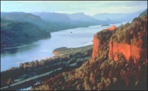 That
long section of Interstate 84 known as the Columbia Gorge Highway is about
the most awesome piece of road in Oregon, or the Pacific Northwest, for
that matter. It connects Eastern Oregon with the rest of the state. If
you look carefully at a map of the state, it is easy to understand that
the population pattern resembles an upside down L made by Interstates
5 and 84. Interstate 5 runs up and down the state, and is the conduit
for probably 85 percent of the population. Most of that is concentrated
in the Willamette Valley which lays between the Columbia River, the northern
border of Oregon, and Eugene at the southern end of the Willamette valley.
Interstate 84 runs across the top of the state and sets next to the Columbia
River until it takes a turn towards the south at Boardman, a tiny town
70 miles west of Pendleton. From then on you are in Eastern Oregon which
is, for all practical purposes, a separate place from the rest of the
state.
That
long section of Interstate 84 known as the Columbia Gorge Highway is about
the most awesome piece of road in Oregon, or the Pacific Northwest, for
that matter. It connects Eastern Oregon with the rest of the state. If
you look carefully at a map of the state, it is easy to understand that
the population pattern resembles an upside down L made by Interstates
5 and 84. Interstate 5 runs up and down the state, and is the conduit
for probably 85 percent of the population. Most of that is concentrated
in the Willamette Valley which lays between the Columbia River, the northern
border of Oregon, and Eugene at the southern end of the Willamette valley.
Interstate 84 runs across the top of the state and sets next to the Columbia
River until it takes a turn towards the south at Boardman, a tiny town
70 miles west of Pendleton. From then on you are in Eastern Oregon which
is, for all practical purposes, a separate place from the rest of the
state.