|
Ripley Roots |
|
|
|||||||||||||
|
< |
Back to Verdun 87 Years Later by Markus Klein
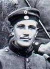
Below is a description of a one-day trek taken by Markus Klein, great grandson of Otto Klein. The purpose of the trip was to retrace his great grandfather's steps where he had been injured during World War I. Otto Klein served in the 22nd Royal Bavarian Infantry Regiment. Otto was injured in either the Forest of Avocourt (March 20-23, 1916) or at the Battle of Hill 304 (May 3- 7, 1916). We are not sure which. A bullet came from the front. It hit a metal stud of his combat pack and the bullet turned and entered his body crosswise short of his heart. The bullet's ricochet caused a very big hole in Otto's back when it left his body.
Markus read extensively before his trip and prepared himself the best he could to find the xact places where the infantry fought. Here is the description of his journey which took place on May 12, 2003, when Markus was 31. Otto was 34 when he was injured in the same area.
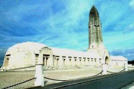
**** 7:00 a.m. the bags I packed yesterday are stored in my car. Something to eat and to drink, old sneakers for walking in the forests, a camera, a German-French dictionary, the Verdun guide- book, xerox copies of the regiment's book regarding Verdun and the out-printed map "harvested" on the internet. I'm heading for the autobahn. I'm entering the autobahn A6 at Saarbrücken and some minutes later, I'm crossing the German-French border. Little traffic, I hear "our" radio broadcasting station until Metz, then only French radio stations. The autobahn in France is not free of charge and so I have to pay two times until I reach Verdun after 1 ½ hours. Entering the city from the south, I'm following the signs "Office du tourisme" (Tourist Office) where I'm intending to purchase the hiking map there. Two young women in the office, one is able to speak German. The map is out of stock and so I have to walk into the pedestrian area where I get the map in a bookshop. The city looks small, the guide-book says 35,000 inhabitants. The houses are built from light grey-yellow limestone. I see the big victory monument leading up 73 steps to 30 meters high, statue-crowned, pillar. Contrary to the Germans in WWI, Verdun-city is not my object of interest, so I'm driving out of the city, direction west. The sky is covered with dark, deep-hanging clouds. I hope it doesn't rain! I'm coming through tiny little villages, "Charney-sur.Meuse", "Marre", "Chattancourt", "Esnes- en-Argone"...I'm happy to have the map! The villages are so small, only 20 buildings, that's all! Between the villages, cattle at pasture, yellow rape, rolling hills. The whole landscape has a completely agricultural character, very little traffic. I'm quite alone on these very (!) narrow streets. They remind me of single track roads in Scotland. On my right side, there is a wooded ridge 1 kilometer away. "Mort-Homme" (dead-man) and "Hill 304"!!! For a short time, I can see the monument on "Mort-Homme". Coming through Esnes-en-Argonne my suspense is rising! The next village is "Avocourt"!!! Between Esnes and Avocourt there is a military cemetery, probably a French one. I can see a French flag, workers are busy with a lawn mower there.
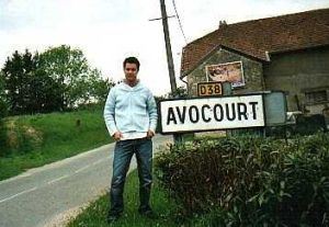
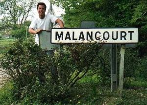
Avocourt...I never thought that it would be such a small village! A dozen buildings and a little church. I stop and take a picture of the entrance sign. The village was never in German hands, only the forest that is north of the village. One minute later I'm through the village and another minute later I can see the "Forest of Avocount". The road that I'm following is the road from Avocourt to Malancourt leading through this forest. Now I'm inside the forest. I speed down and look at the right and left. Fir and spruce are standing very closely, so I cannot look "inside" the dark forest. According to the regiment's book I know where the trenches and dugouts were "in the forest between Avocourt and Malancourt, 500 meters out of the road between these villages." In the middle of the forest there is a forest road in a forest lane that is very good and straightforward south. That's my road!! Now I'm exactly at the place where I wanted to be! I'm driving slowly on this road and I'm very excited. Eighty-seven years later I'm driving with my car over the German lines of March 1916. The sky is dark with clouds but it's still not raining. About 500 meters the road ends in a clearing. Perfect! I'm on the exact place the regiment's book is speaking about. I stop the engine and put on my old shoes. I intend to make a small hiking tour in the forest. Looking at the map, I see the forest is divided in rectangular sections like a chess board. Each section has a number and this number is written on little boards on trees. Between the sections there are wood paths made for tractors or logging machines. I decide to take the wood path between section 21 and 22.
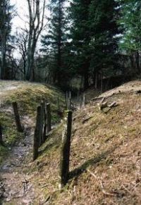
Now I'm really, really inside the forest! It's very dark, due to the cloudy sky and the close standing firs. The forest floor, right and left of the wood path, is very uneven. Craters with up to 2 meters diameter are covering the forest floor. Little "hills" everywhere. It's difficult to say if they are "hills" or rims of the craters. Countless hollows and troughs in a zig-zag line, the former trenches. The firs are standing everywhere, in the craters, on the "hills", in the hollows, at the rim of the hollows...everywhere. It's impossible to take a picture of the structure of the forest floor. First, it's much too dark and second the relief of the ground cannot be seen very well because of the close standing trees and thicket. Alas, here was the sector where the 22nd infantry regiment waited for the battle, fought and won the forest. All the essays from the regiment's book that I read often in the last weeks are coming to mind again. The wood path is muddy and I'm happy that I have my old shoes on. It's slippery, but I'm walking straight on the path deeper and deeper into the forest. I think I must be the only person in the whole forest. Since Avocount I have not seen a single person. Suddenly, I discover thin bamboo sticks with a red marker sticking in the forest floor. I suppose they indicate ammunition finds. Luckily, there are quite far away from the wood path where I'm walking. I'm sure the wood path is safe because I see impressions of tires from tractors and other heavy machines in the muddy soil. After 15 minutes I'm reaching the corner of my rectangular "chess board section" and I'm turning left. After some meters, my heart is standing still for one moment.
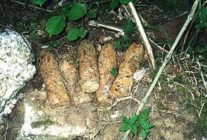
Directly next to me, ammunition on the wood path! Five or six rusty shells, 15-20 centimeters long, 7-10 centimeters diameter. They are not exploded when they hit the ground in WWI. They are absolutely complete, I can see the fuze. I'm absolutely shocked that they are lying around here on the wood path waiting to be disarmed. I turn around and I see another eight or nine shells on the other side of the wood path! I feel panic and fear coming up. I'm absolutely alone in this dark and lonely forest, and I don't want to be the last victim of WWI. My great grandfather was probably injured in this forest, but I do not want so. My heart is beating when I take a picture of the shells and go further quickly. I have a very bad feeling walking around on this former battlefield. Suddenly I see a family of wild boars crossing the wood path 30 meters in front of me. I remember the story Christine told me about her grandfather. One time he was hunted by them when he took a walk. I decide to get to my car as soon as possible, I have had enough! Not only that I'm walking around on a dangerous battlefield, I also feel persecuted by wild boars. I take the wood path between section 17 and 18 and I set one step in front of the other and I'm carefully watching not to walk on ammunition. The lumber jacks here in the forest are poor guys!!
I'm happy to be at my car again and drive out of this damned forest. Coming to the road Avocourt-Malancourt, I'm turning right to the direction of Malancourt. I'm to the village after five minutes. Everything is very close here. Malancourt is as big as Avocourt, 10-20 buildings altogether. I take again a picture of the entrance sign and the church. Malancourt is mentioned in the regiment's book very often. It was in German hands in and after March 1916. I think my great grandfather must have been here very often. Leaving Malancourt I'm coming to a sign that says, "Haucourt-village detruit" (Haucourt- destroyed village). I remember the regiment's book mentioned this village. Today, there is nothing other than this sign, the former village is completely destroyed. Shortly after the sign I'm driving over a small rivulet. It's the "Forgesbach", mentioned in the regiment's book very often.
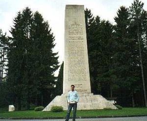
Now the road leads up to Hill 304, after 5 minutes I'm on the top. In 1916 it took weeks for the Germans to reach it. The road was also existing in March 1916 and both sides fought hard over it. On the top there is a big stone monument, mentioning the French regiments that defended Hill 304. The German regiments are not mentioned. I'm here in the winner's land. I take a picture of the monument, the place is lovely, the lawn is mowed, a board is explaining what went on here long ago. In my guidebook , on the map, and on the visitor's guide sign at the monument there is the same proposed hiking tour of Hill 304. I'm convinced that it is safe, so I follow the blue signs. Like in the forest of Avocourt the soil looks like the surface of the moon. It is impossible to distinguish between craters, trenches, or simple holes. The fir trees stand very close. Here on the marked way I am able to make the first picture of the dug up terrain.
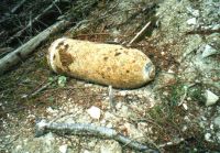
After 300 meters I am coming to a wood path called "shell's road." What a nice name! I turn right and follow this "shell's road." After a while, I know why the road is called so, next to the path lies an unexploded shell. This time I am not so excited anymore. Funny how quickly one gets accustomed to this dangerous air. There are a lot of little iron pieces on this wood path. Carefully examined I come to the conclusion that they are fragments of detonated shells and bombs. I take some with me as a souvenir. The weather is getting better, the sun is shining, I pull out my pullover. I am walking down Hill 304, but of course only on the wood path marked in my map and where I can see impressions of tires or horseshoes. This is my tribute to safety I have to pay. I reach the bottom of Hill 304 and walk ahead to the small rivulet "Forgesbach" that is mentioned often in the regiment's book. Hill 304 is completely covered with trees today but here are meadows, some cattle behind fences. The essays in the guidebook talk about the rivulet area as a swampy lowland, but today it is dry. I reach the rivulet, but the lane that I intend to take to Malancourt is not existing. The map is wrong! A young girl on a horse is coming along and says "The lane is not existing anymore but you can walk through the forest!" (She is talking about the forest that covers Hill 304). I ask, "Is this possible? Is it safe?" She says, "Yes, certainly." I think of all the shells I have seen and I decide not to trust her opinion. I go back to the meadows, next to the lane lies a shell about 60 centimeters long, 10-15 centimeters diameter. It seems a farmer found it when he plowed his field and threw it away like rubbish. I decide not to become a farmer here.
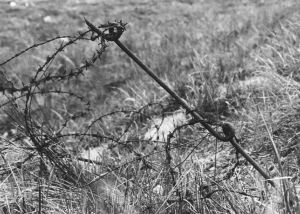
Again at the bottom of Hill 304, a big heap of rusty barbed wire bars my way. On the same way back on "shell's road" and to the top of Hill 304, I try again to take a picture from the craters, holes and trenches. The relief of the soil is so bizarre!! I make five steps into the brushwood...a big shell is lying directly in front of my feet. It is a big thing in perfect condition and I can even read the numbers on the fuze. I am frightened again and I swear never to go in the brushwood again. I come back to my car thirsty and drive down Hill 304 again, coming through Malancourt. I stop and ask a man, "excuse me, where is Azannes?" He replies it is on the other side of the Maas River and he shows me the place on the map. I always thought it must be in the near to Malancourt, but it is far away. I do not think my grandfather got his first aid in Azannes. I drive through "Montfaucon" to see an American monument and arrive in "Ivoiry" where the regiment's book said, "...in Ivoiry are the field-kitchens." Today, Ivoiry is a place with five buildings and a completely destroyed church. It is 4 p.m. now and I decide to drive to the eastern battlefields on the other side of the Maas River which I visited in 1994. I arrive half an hour later and everything is still familiar to me. But it is a complete contrast to the battlefields in the forest of Avocourt and Hill 304. The battlefield is clean here, picnic area, guide boards on every corner, sign posts for tourists, the lawn is mowed. It looks like a park, not a battlefield. One can also see the craters and the former trenches, but they are "clean, no weeds, no brushwood, lawn has been sowed over the hilly terrain. It is a postcard battlefield if you compare it to the battlefield on Hill 304 or the Forest of Avocourt.
I visit "Fort Vaux" and "Fort Souville", both ortifications that played important roles in the battle in 1916. In the end I visit the "Ossuaire" where skeletons of 130,000 unknown soldiers are kept in big stone caskets. In each casket there is a little window where you can see the skulls, leg bones, hip bones...Disgusting! I am so tired of seeing death. I decide to stop this trip. I return to Verdun (only 4 kilometers away!) and enter a big shopping mall. I am so happy to be around living people again! I buy some French wine, French sausage, and French bread for my supper this evening and drive back to Webenheim again.
|
||||||||||||
|
© 2014 Theresa Ripley |
|||||||||||||